What is the issue?
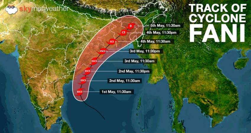
- A powerful cyclonic storm named Fani is headed towards the Odisha coast.
- As a cyclone in Bay of Bengal in April-May season, of this nature, is unusual, it is essential to understand the causes.
How do tropical cyclones form?
- Cyclones are formed over slightly warm ocean waters.
- It depends on the temperature of the top layer of the sea, up to a depth of about 60 metres.
- This has to be at least 28°C to support the formation of a cyclone.
- This explains why the April-May and October-December periods are conducive for cyclones.
- Secondly, the low level of air above the waters needs to have an ‘anticlockwise’ rotation in the northern hemisphere and vice versa.
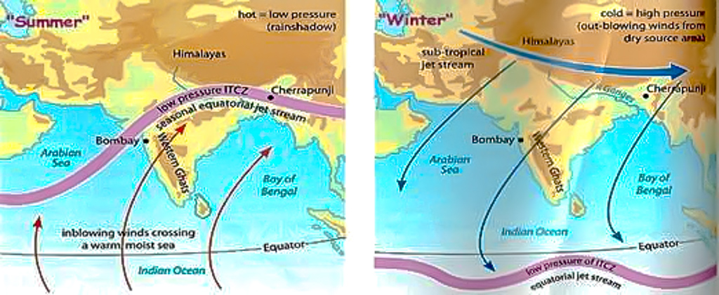
- During these periods, there lies the Inter-Tropical Convergence Zone (ITCZ) (a low pressure zone) in the Bay of Bengal region, which shifts with seasons.
- The southern boundary of the zone experiences winds from west to east and the northern boundary from east to west.
- The ITCZ and the resultant wind pattern induce the anticlockwise rotation of air.
- Once formed, cyclones in this area usually move northwest.
- As it travels over the sea, the cyclone gathers more moist air from the warm sea, and adds to its strength.

How prevalent are tropical cyclones in India?
- Cyclones are a normal event in the eastern coast of India.
- On an average, five to six significant cyclonic storms emerge in the Bay of Bengal region every year.
- The prime seasons for tropical cyclones are
- the months of April and May, just before the start of the summer monsoon
- October to December, immediately after the end of the summer monsoon
- Cyclones emerging in April-May are usually much weaker than those during October-December.
- Most of the cyclones in April-May move northeast to hit Bangladesh, Myanmar or other countries in the Southeast Asian region.
- There have been only 14 instances of a “severe cyclone” forming in the Bay of Bengal region in April since 1891.
Why are Oct-Dec cyclones more strong?
- A thumb rule for cyclones is that the more time they spend over the seas, the stronger they become.
- [E.g. Hurricanes around the US, which originate in the vast open Pacific Ocean
- They are usually much stronger than the tropical cyclones in the Bay of Bengal, a relatively narrow and enclosed region.]
- In India, cyclones in October-December are usually remnants of cyclonic systems that emerge in the Pacific Ocean.
- They manage to come to the Bay of Bengal, considerably weakened after crossing the Southeast Asian landmass near the South China Sea.
- However, these systems already have some energy, and gather momentum as they traverse over the Bay of Bengal.
- Notably, April-May is not the season for typhoons in the west Pacific Ocean.
- Most of the typhoons, in northern hemisphere, form between June and November.
- So cyclones in April-May originate in situ in the Bay of Bengal itself.
- This is barely a few hundred kilometres from the Indian landmass, and hence the cyclones are relatively weaker.
How and why is Fani different?
- Tropical cyclones in the Bay of Bengal are graded according to maximum wind speeds at their centre as follows:
- depressions - 30 to 60 km per hour (kph)
- cyclonic storms - 61 to 88 kph
- severe cyclonic storms - 89 to 117 kph
- very severe cyclonic storms - 118 to 166 kph
- extremely severe cyclonic storms - 167 to 221 kph
- super cyclones - 222 kph or higher
- Fani is now categorised as an “extremely severe cyclone”.
- It is expected to generate storms with wind speeds as high as 200 km per hour.
- It has the potential to cause widespread damage in Odisha and neighbouring states.
- Given the above discussed reasons, a cyclone of this nature is unusual for April-May cyclones in India.
- Fani is different mainly on account of its place of origin, and the route it has taken.
- Origin - The in situ cyclonic systems in the Bay of Bengal usually originate around latitude 10° N (in line with Chennai).
- But Fani originated quite close to the Equator, around latitude 2° N, well below the Sri Lankan landmass.
- The forecast landfall on the Odisha coast is at a latitude of almost 20°N.
- As it has originated very close to the Equator, it has taken a long route to reach the landmass.
- Resultantly, it has traversed a long way on the sea, and thus gained more strength.
- Route - Fani was initially headed north-westwards, towards the Tamil Nadu coast.
- But it changed its course midway and moved northeast away from the coastline to reach Odisha.
- The recurve it has taken gave it more time over the sea and has ensured that it has gathered unusual strength.

Source: Indian Express

