What is the issue?
- Cyclone Titli recently hit the Odisha-Andhra coastal zone.
- Given the cyclone frequency in the Eastern Coast, it is essential to understand about cyclone formation and evacuation process.
How has the cyclone trend been?
- Titli is the third major cyclone to hit the Odisha-Andhra coastal zone in the last five years, all in October.
- The other two are the Phailin (2013) and Hudhud (2014) cyclones.
- Cyclones have always been frequent in the Odisha-Andhra coastal region.
- But notably, the frequency of intense cyclones in the area has increased over the years.
How do they form?
- Pacific is one of the world’s most active basins for typhoons, and adjacent to the northwest of this is the Bay of Bengal.
- Notably, Bay of Bengal receives the remnants of major landfalls in the Philippines, China and South Asia.
- From these places come low-pressure systems that develop into a monsoon depression or a cyclone.
- This is the reason why most of the cyclones such as Titli, Phailin and Hudhud typically struck in October.
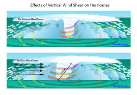
- The reason is that wind shear i.e. the difference within wind speeds and direction at two different levels is low during this time.
- The low wind shear, when combined with surface sea temperatures greater than 26°C, raises the likelihood of cyclones.
- This is because, if there’s too much wind, these weather systems have trouble organizing and developing into a tropical cyclone.
- But with little to no wind shear, the turning within the tropical system is uniform.
- So the storm becomes vertically aligned, helping to keep it intact and, likely, strengthening.
Why is it hard to predict?
- India acquires storm prediction models from the US and Europe but lacks the resources to upgrade the models regularly.
- The Odisha government was criticised for being unable to anticipate the landfall of Cyclone Titli or the very heavy rainfall.
- But prediction is difficult here because of budgetary and meteorological factors.
- In the Atlantic basin, the US has dedicated aircraft that fly directly into the clouds.
- It studies moisture levels and gather various data on cyclone profile.
- But for Indian cyclones developing over the ocean, the reliance is largely on satellite images (a top view).
- This only reveals little data on moisture content and intensity.
- So getting a more detailed picture is possible only when a cyclone is 300-400 km from the coast.
- But this reduces the prediction and preparation time.
- Specifically, Cyclone Titli was hard to read because it turned into a recurving cyclone (it changed direction).
How is evacuation done?
- Evacuation exercises are classified as preventive, vertical, and shelter-in-place.
- In preventive (or horizontal) evacuation, the impact area is meant to be completely evacuated.
- But this is a measure rarely taken in India because of poor roads and inadequate public transportation.
- Also, poor people rarely have the resources to find alternative accommodation.
- In vertical evacuation, people are directed to specially designed buildings within the impact area, which was largely followed during Cyclone Titli.
- Shelter-in-place evacuation involves fortification of existing houses and community buildings, which again required financial resources.
- Concerns - Reportedly, the government does not have adequate multipurpose cyclone shelters.
- The government claimed around 3 lakh people were successfully evacuated during Cyclone Titli.
- But widely held parameters of success in disaster management, such as number of evacuees, are “misleading”.
- Notably, the fewer casualties during Phailin and Hudhud were because of the limited severity of these cyclones than effective disaster planning.
Source: Indian Express
