Why in news?
The Union Minister for Environment, Forest and Climate Change recently released the biennial “India State of Forest Report (ISFR)” for 2019.
What is the ISFR?
- The report is published by the Forest Survey of India (FSI).
- FSI has been mandated to assess the forest and tree resources of the country including wall-to-wall forest cover mapping in a biennial cycle.
- Starting 1987, 16 assessment have been completed so far. ISFR 2019 is the 16th report in the series.

What are the key findings?
- Rankings - Area-wise, Madhya Pradesh has the largest forest cover in the country.
- This is followed by Arunachal Pradesh, Chhattisgarh, Odisha and Maharashtra.
- In terms of forest cover as percentage of total geographical area, the top 5 States are:
- Mizoram (85.41%)
- Arunachal Pradesh (79.63%)
- Meghalaya (76.33%)
- Manipur (75.46%)
- Nagaland (731%)
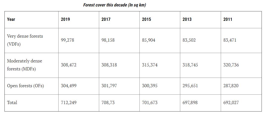
- Share - India’s forest cover has increased by 3,976 sq km or 0.56% since 2017.
- For the second successive time since 2007, the SFR recorded a gain (an impressive 1,275 sq km) in dense forest.
- This includes Very Dense Forest with a canopy density of over 70%, and Moderately Dense Forest with a canopy density of 40-70%.
- Around 2,140 sq km of dense forests became non-forests since 2017.
- [A dense forest can deteriorate into an open forest (10-40% canopy density) but conversion to non-forest signifies total destruction.]
- Since 2017, plantations with high canopy density have added 2,441 sq km to the dense forest category.
- On the other hand, 1,858 sq km of non-forests have become dense forests.
- These are plantations of fast-growing species since natural forests rarely grow so fast.
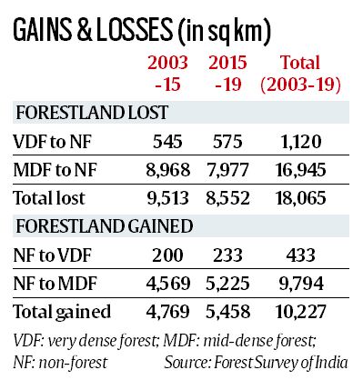
- Since 2003, close to 18,000 sq km of dense forests have become non-forests in the country.
- Nearly half of this (8,552 sq km) were in the last 4 years alone.
- While hill forests have gained in quality, large tracts of tropical forests have fallen off the “dense” category since 2017.
- The biggest loss is under the tropical semi-evergreen head in SFR 2019 - close to 23,500 sq km.
- [In India, tropical semi-evergreen forests are found along the western coast, lower slopes of the eastern Himalayas, Odisha and Andamans.]
- Of India’s 7.12 lakh sq km forest cover, 52,000 sq km is plantations.
- This means that it cannot substitute natural forests in biodiversity or ecological services.
- Of the nearly 7,28,500 sq km recorded forest area, around 2,15,000 sq km (nearly 30%) recorded no forest cover in SFR 2019.
- In other words, forestland roughly the combined area of Tamil Nadu and West Bengal holds no forests.

- The total mangrove cover in the country is 4,975 sq km.
- An increase of 54 sq Km in mangrove cover has been observed as compared to the previous assessment of 2017.
- Top three states showing mangrove cover increase are Gujarat (37 sq km) followed by Maharashtra (16 sq km) and Odisha (8 sq km).
- The extent of bamboo bearing area of the country has been estimated 16 million hectare.
- There is an increase of 0.32 million hectare in bamboo bearing area as compared to ISFR 2017.
- Under the current assessment, the total carbon stock in the country’s forest is estimated at around 7,100 million tonnes.
- There is an increase of 42.6 million tonnes in the carbon stock of the country as compared to 2017.
- The annual increase in the carbon stock is 21.3 million tonnes, which is 78.2 million tonnes CO2 equivalent.
Source: Indian Express, PIB

