0.3022
7667766266
x

India’s Seismic Zone Maps

iasparliament Logo
January 21, 2023

What is the issue?

  1. Joshimath, a town in Uttarakhand, is in the midst of a crisis as many houses in the town have developed major or minor cracks.
  2. Joshimath is located in Zone V (high-risk area) of India’s seismic zone map. Let’s look at the seismic zone maps of India and its history.

To read about the Joshimath Crisis, click here.

What are seismic zones?

  • A seismic zone is an area where there is a high probability of earthquakes due to the area’s geology.
  • Seismic zonation involves dividing areas based on expected ground motion.
  • It assesses the hazards related to earthquakes in such areas to provide inputs for safer constructions and other practices.

According to the Journal of the International Society for the Prevention and Mitigation of Natural Hazards, almost 65% of India falls in high to very high seismic zones.
What is the history of India’s Seismic Zone Maps?

  • 1935 - The first national seismic zoning map of India was compiled by the Geological Survey of India in 1935, after the 1934 Nepal-India earthquake that measured over 8.0 on the Richter scale.
  • It consisted of three zones - severe, light, and minor hazard, “based on the broad concept of space-time earthquake statistics and the prevailing understanding of geotectonic” movements.
  • 1962 - In 1962, the Bureau of Indian Standards (BIS) published a seismic zonation map of India.
  • This map marked earthquake epicentres in the country and built on the isoseismic map published by the GSI in 1935.
  • It divided India into seven zones - from 0 (no damage) to VI (extensive damage). It was reviewed in 1966, using geological and tectonic features.
  • 1970 - In 1967, a 6.3-magnitude earthquake struck the Koyna hydroelectric project led to revisions in 1970 seismic zone map of India.
  • The 1970 map consisted of 5 zones (I, II, III, IV, V) based on the Modified Mercalli Intensity (MMI) scale with a Comprehensive Intensity Scale (CIS-64).
  • The MMI scale takes into account the effect of earthquakes on people, objects, and buildings, and estimates the shaking intensity from an earthquake at a specific location.
  • Zero was removed as a zone since it was deemed scientifically inappropriate to consider a region completely safe from earthquakes.
  • Another major change in the 1970 version of the map was the merging of zones V and VI.
  • In 1984, a new update to India’s seismic zone map was released. This map identified the seismic potential of regions based on past earthquakes as well as its tectonic features.

How did the seismic zone maps looked after 1984?

  • Till 1984, IS 1893 was the main seismic code of India, and all seismic zone maps were based on it.
  • This code was revised in 1966, 1970, 1975, and 1984. In 1991, it was decided that IS 1893 would be split into parts.

How does the latest seismic zone map of India look like?

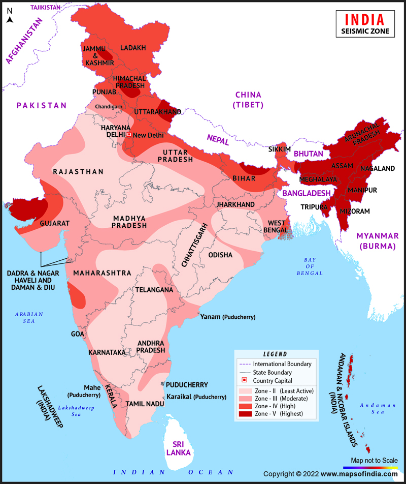
  • According to the latest version of India’s seismic zone map (2002), earthquake-prone regions in the country are divided into four zones (II, III, IV, and V) based on intensity levels during past earthquakes.
  • Approximately 11% area of the country falls in zone V, 18% in zone IV, 30% in zone III and the remaining in zone II.

india-map-seismic-zone

According to the revised IS 1983-2002 seismic code, seismic zones are mapped to a modified CIS-64 scale, an alternative to the MMI scale for seismic zoning.

Seismic Zones of India

Intensity of the Seismic zone (based on modified CIS-64 scale)

Zone II

Areas that are prone to earthquakes mapped to intensity of VI and below

Zone III

Areas that are prone to earthquakes mapped to intensity VII

Zone IV

Areas that are prone to earthquakes mapped to intensity VIII

Zone V

Areas that are prone to earthquakes mapped to intensity IX and above

  • Zone II, which was made by combining areas under zone I and II, indicate areas of under intensity.
  • Zone III is the next classification and includes areas that are prone to earthquakes of moderate intensity.
  • Zone IV includes areas prone to earthquakes of severe intensity, and include Patna, Pilibhit, Ludhiana, Roorkee, Gorakhpur, and Amritsar.
  • Zone V is the most seismically active zone. This includes
    • the entire northeast India,
    • parts of northwestern Bihar,
    • Kangra Valley in Himachal Pradesh,
    • Andaman and Nicobar Islands,
    • eastern part of Uttarakhand,
    • Rann of Kutch in Gujarat, and
    • Srinagar area in Jammu and Kashmir

Reference

  1. The Hindu Explained | Joshimath crisis: A brief history of India’s seismic zone maps
  2. Maps Of India | Seismic Zoning Map of India
Login or Register to Post Comments
There are no reviews yet. Be the first one to review.

ARCHIVES

MONTH/YEARWISE ARCHIVES

sidetext
Free UPSC Interview Guidance Programme
sidetext