A recent study suggests that an earthquake about 2,500 years ago might have abruptly altered the course of the Ganga River.
It is a sudden and rapid shaking of the Earth's surface.
Generation – It is caused by the release of energy stored in the Earth's crust which generates seismic waves, which propagate through the Earth and cause the ground to shake.
A seismic wave is a mechanical wave of acoustic energy that travels through the Earth or another planetary body.
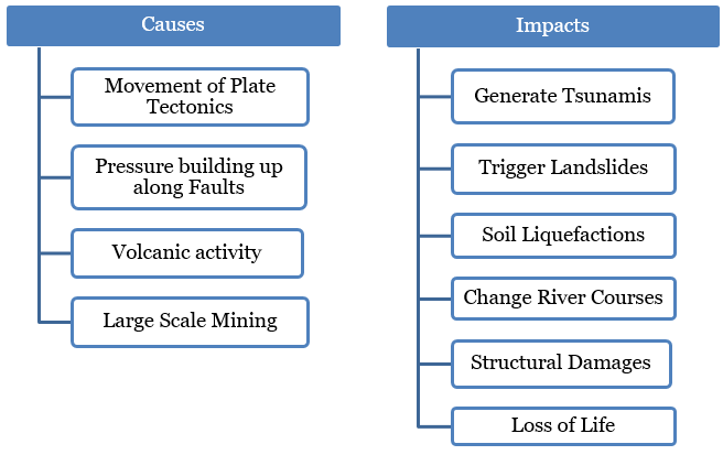
Displaces riverbeds- Earthquake can cause the ground to shift, and can alter the course of rivers by moving their beds or changing their direction.
Alters water flow patterns- Shifts in the riverbed or new obstacles can change the speed and volume of river flow.
Blockage by Landslides- Landslides due to earthquake can block rivers and form temporary or permanent dams.
Alters sediment load- An increase in sediment flow into rivers due to landslides or soil erosion, affects river morphology.
Creates new channels- All these factors can result in creating new pathways for rivers, leading to the formation of new river channels.
The Ganga River, originating in the Himalayas, merges with the Brahmaputra and Meghna rivers before flowing into the Bay of Bengal, forming the world’s second-largest river system after the Amazon.
Discovery of Paleochannel - Using satellite imagery, researchers identified the former main channel of the Ganga, about 100 km south of Dhaka, Bangladesh.
It is approximately 1.5 km wide and extending for about 100 km, runs almost parallel to the current river course.
A paleochannel is a section of an old river that is no longer part of an active fluvial system and carries no more fluvial discharge.
Presence of Sand dikes- Two large sand dikes were found to the east of the paleochannel showing earthquake-induced liquefaction.
Sand dikes are geological structures formed when sediment, typically sand, is injected into fractures within a rock or sedimentary layer.
The sand dikes and their composition, consisting of “fine sands” and “silty muds” provided conclusive evidence of a major ancient earthquake.
Sources of earthquake - Researchers found features known as seismites in this area, indicating earthquake activity which might be
From a subduction zone to the south and east, where an oceanic crust plate is pushing under Bangladesh, Myanmar, and northeastern India (or)
From faults at the Himalayas' base, which are rising due to the Indian subcontinent's collision with Asia.
Similar timing of earthquake & avulsion of river course – The mineral samples from the sand dikes and the paleochannel were tested under optically stimulated luminescence (OSL) dating.
Optically stimulated luminescence (OSL) dating technique relies on estimating how long a mineral grain (i.e. a mineral particle less than a few millimetres in size, like quartz grains in sand or mud) has been buried by measuring the amount of natural radiation stored in it.
Paleochannel samples – It reveals that the avulsion occurred around 2,500 years ago.
Sand dikes samples – It shows that dikes had been formed around 2500 years ago confirming occurrence of earthquake.
Thus the OSL technique of samples helped in strengthening their hypothesis that the earthquake led to the avulsion.
What are significances of the recent findings?
It suggests that the impact of large earthquakes can be even more devastating than previously thought because avulsions have caused some of the deadliest floods in human history.
The cascading impacts of earthquakes and flooding can be severe for heavily populated regions like the Ganges-Meghna-Brahmaputra delta.
Rivers Ganges are more prone to avulsion now owing to factors like
Rapid subsidence, i.e. sinking of the ground near the river banks due to “widespread embankment
Climate-change–induced rise in sea levels and extreme weather events
Thus the lessons learned from this ancient earthquake may hold important insights for navigating the Ganga's ever-changing course in the years to come.
Future research should focus on finding the frequency of such quake-driven avulsions have happened and how such major earthquakes can be forecast.
Policy makers and the residents of the Ganga delta should prepare themselves against the risk from such avulsions.
India, Bangladesh and Myanmar should work closely in terms of research, monitoring, preparedness, and support coordination.