0.2201
7667766266
x

India’s Forest Cover Data

iasparliament Logo
March 03, 2023

Why in news?

India has a scientific system of periodic forest cover assessment, providing valuable inputs for planning, policy formulation and evidence-based decision-making.

What is the status of forest and tree cover in India?

  • FSI – The Forest Survey of India (FSI) started publishing its biennial State of Forest reports in 1987, however, it has been mapping India’s forest cover since the early 1980s.
  • India – It counts all plots of 1 hectare or above, with at least 10% tree canopy density, irrespective of land use or ownership, within forest cover.
  • This disregards the United Nation’s benchmark that does not include areas predominantly under agricultural and urban land use in forests.

The global standard for forest is provided by the Food and Agriculture Organisation (FAO) of the United Nations: at least 1 hectare of land with a minimum of 10% per cent tree canopy cover. It does not include areas predominantly under agriculture or urban land use in a forest.
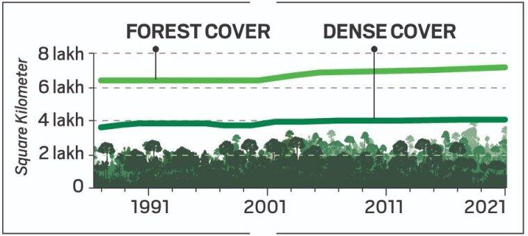
Forest cover 2023

  • Dense and Open Forests – All land areas with tree canopy density of 40% and above are considered dense forests and those between 10-40% are open forests.
  • Very Dense Forests – Since 2003, a new category, very dense forest, was assigned to land with 70% or more canopy density.
  • Isolated Trees – Since 2001, small patches of trees less than 1 hectare and not counted as forest.
  • They are assessed for determining a notional area under tree cover by putting together the crowns of individual patches and trees.

How are the data from NRSA and FSI interpreted?

  • The National Remote Sensing Agency (NRSA) under the Department of Space estimated India’s forest cover using satellite imagery.
  • Encroachment – Nearly the size of Haryana of forest land was diverted for non-forest use between 1951 and 1980.
  • Old forests lost – Land recorded as forest in revenue record, proclaimed as forest under a forest law is described as Recorded Forest Area.
  • Over time, some of these Recorded Forest Areas lost forest cover due to encroachment, diversion, forest fire etc.
  • In 2011, it came to light that nearly one-third of Recorded Forest Areas had no forest at all.
  • National forests shrink – Even after extensive plantation by the forest department since the 1990s, dense forests within Recorded Forest Areas added up to cover only 9.96% of India in 2021.
  • That is a one-tenth slide since the FSI recorded 10.88% dense forest in 1987.
  • Natural vs manmade – The steady replacement of natural forests with plantations are worrisome.
  • Natural forests are old and therefore stock a lot more carbon in their body and in the soil.
  • Plantation forests have trees of the same age, are more susceptible to fire, pests and epidemics, and often act as a barrier to natural forest regeneration.
  • Impact of technology – The forest cover fluctuated with every change in technology and the radical refinement in 2001 made the data incomparable with the previous assessments.

What is the way forward?

  • The forest maps are based on the images purchased from NRSA, another arm of the government.
  • Brazil Model – Even though Brazil is losing forests at an alarming rate, their forest data is open and free.
  • Brazil’s National Institute for Space Research (INPE) maintains an open web platform, TerraBrasilis, for data on deforestation, forest cover change and forest fire.
  • With environmental awareness on the rise, thousands of researchers and enthusiasts can volunteer to verify the country’s forest data on the ground and be proud custodians of this vital national asset.


Reference

  1. Indian Express │The case for open, verifiable forest cover data
Login or Register to Post Comments
There are no reviews yet. Be the first one to review.

ARCHIVES

MONTH/YEARWISE ARCHIVES

sidetext
Free UPSC Interview Guidance Programme
sidetext