0.2342
7667766266
x

Challenges in ENSO/Monsoon Forecast

iasparliament Logo
March 20, 2025

Why in News?

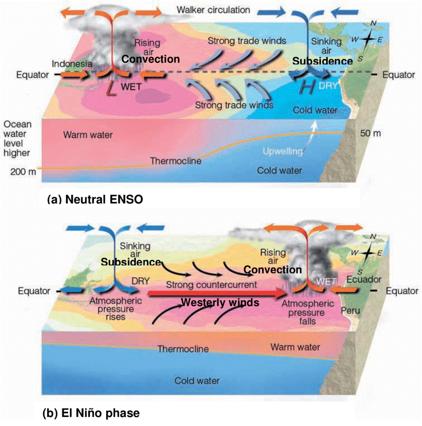
The evolution of sea surface temperature (SST) patterns in the tropical Pacific Ocean from 2024 has raised concerns in predicting global weather.

What is El Nino-Southern Oscillation?

  • El Nino-Southern Oscillation (ENSO) – ENSO is an ocean -atmospheric phenomena characterized by fluctuating temperatures in the central and eastern equatorial Pacific Ocean.
  • El Nino – It is the warm phase of ENSO in the central and eastern Pacific with weak trade winds.
  • La Nina It is the cool phase of ENSO in the eastern Pacific, strengthening trade winds.

enso

  • Indian Ocean Dipole (IOD) –  It is a climate pattern characterized by alternating warm and cold sea surface temperatures in the western and eastern Indian Ocean, impacting rainfall patterns and monsoon intensity.
  • It can influence Indian monsoon, where a positive IOD can counteract the negative effects of El Nino.
  • ENSO Transition Mode (ETM) – It is a climate mode that modulates the seasonal transition of El Niño-Southern Oscillation (ENSO) from boreal winter to summer, particularly in the Southern Hemisphere.


Effect of ENSO on India’s Monsoon

  • La Nina - Cold SSTs in the eastern/central Pacific strengthen easterly trade winds, boosting the monsoon (June-September). This often means more rain for India—good for farmers.
  • El Nino - Warm SSTs weaken the monsoon winds, often leading to less rain or drought.
  • Neutral - When neither La Nina nor El Nino dominates, the monsoon can be average, but other factors (like the Indian Ocean) play a bigger role.

What are the challenges in predicting ENSO and Monsoon?

  • Inconsistency - only 60% of deficit and surplus years have historically been accounted for by El Niño and La Niña events.
  • SST anomalies – Traditionally, La Nina is marked by cold SST in the eastern Pacific, while El Nino features warm SST in eastern and central Pacific.
    • Anomaly - However, in 2024 the year predicted for La nina, the cold SST anomalies began shifting westward, with warm SST anomalies in the far east by early summer 2024.
  • This unusual distribution contrasts with historical ENSO patterns, making predictions unreliable.
  • Wind pattern anomalies – ENSO states are also driven by wind patterns, particularly the strength and direction of trade winds.
    • Anomaly - Strong easterly anomalies blew in the central-western tropical Pacific even as there were westerly anomalies in the far eastern tropical Pacific.

Easterlies winds blow from east to west and Westerlies blow from west to east.

  • Dateline El Nino (Central Pacific El Nino) – It is a type of El Niño event characterized by the strongest sea surface temperature warming in the central equatorial Pacific, near the International Dateline.
  • In the last few decades, the reverse pattern — with warm SST anomalies around the dateline and cold SST anomalies around the Galapagos — has been more common and affecting ENSO cycle.
  • El Niño “flavours” – El Niño events are categorized into "flavors" based on the location of the strongest sea surface warming in the tropical Pacific Ocean, with the two main types being Eastern Pacific (EP) and Central Pacific (CP) or Modoki El Niño.
  • These flavours also affect the development of usual ENSO cycle.
  • Failed La Nina Transition –   ENSO cycle usually transitions among El Nino – Neutral – La Nina phases.
  • Sometimes, these transitions failed to make effect.
  • Forecasts in early 2024 projected a strong La Nina to emerge by mid-year.
  • The ETM-induced wind anomalies might have prevented the smooth shift from El Nino to La Nina.
  • Impact of Indian Ocean Dipole – Despite a strong El Nino in 2023, the Indian monsoon remained normal, possibly due to a positive Indian Ocean Dipole (IOD).
  • The pre-monsoon cyclone activity, influenced by ENSO shifts, is also modifying monsoon onset and distribution.
  • Jet Stream Meandering – The relationship between ENSO and the monsoon itself has changed in recent decades.

Jet stream is a fast-moving air current high up in the atmosphere that generally blow from west to east.

  • The jet stream usually helps guide weather systems, but as it shifts and meanders in new ways, it is causing changes in temperature and weather patterns, especially in the middle latitudes.
  • As a result, it is harder to predict the timing and behaviour of the monsoon.
  • Influence of global warming – The record-high global temperatures of 2023 and 2024 may be affecting ENSO cycles.
  • Typically, cooling in the eastern Pacific during La Nina allows the ocean to absorb heat, but persistent warm anomalies suggest the ocean is struggling to regulate heat uptake.
  • Without a well-defined ENSO phase, climate patterns become harder to predict, impacting global weather systems, including the Indian monsoon.

What lies ahead?

  • Better models are needed to predict unusual patterns like the 2025 confused ENSO state and improve monsoon forecasts.
  • More real-time data from oceans and winds can help us understand shifting SSTs and refine 2025 predictions.

Reference

The Hindu | Difficulty in Predicting ENSO

Login or Register to Post Comments
There are no reviews yet. Be the first one to review.

ARCHIVES

MONTH/YEARWISE ARCHIVES

sidetext
Free UPSC Interview Guidance Programme
sidetext