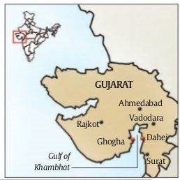
Industrial pollution has destroyed local fisheries in Dahej near Bharuch, Gujarat.
Dahej
Location - Near the ancient port site of Barygaza (near today’s Bharuch) on the Gulf of Khambhat, Gujarat.
Economic importance - It began to be developed as a Special Economic Zone (SEZ) in 1990.
It is one of the four Petroleum, Chemical and Petrochemicals Investment Regions (PCPIR) in the country.

Ecological significance - The freshwater of the Narmada enters the saline waters of the Gulf of Khambhat in Dahej.
Many types of sea life including shrimp, bumla, salmon, boi, makul are found here.
It is also the breeding ground of the Hilsa (‘palwa’ in Gujarat) fish.
Gujarat has the longest coastline in the country (1,600 km) and an Exclusive Economic Zone covering an area of 0.214 million square kilometres.
Effects of industries on Dahej
Dahej is witnessing the increasing stench of chemicals in the air, turbid sea water and decreasing of fish population.
The Gujarat Ecology Commission, in its environmental strategy for the year 2014-2019, found Bharuch district to be critically polluted in terms of industrial waste.
Down to earth | Just Transition in Petrochemicals
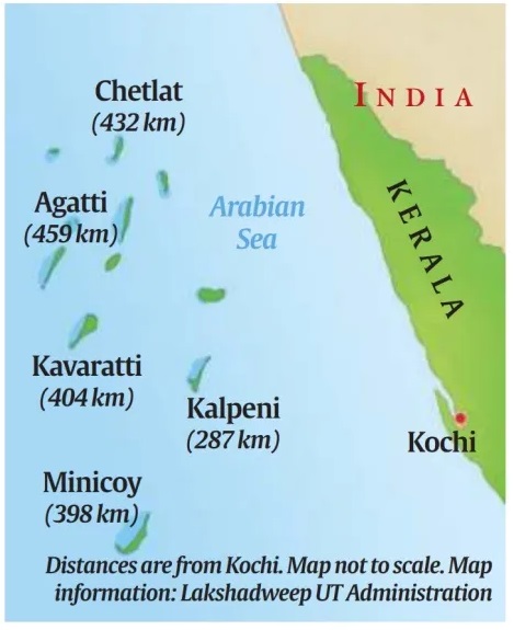
The Indian Air Force (IAF) has proposed to set up a forward fighter airbase in Minicoy Islands, to safeguard the sea lanes of communications and to keep the Arabian Sea free from non-state actors in the region.
Location - In the Indian Ocean between the Laccadive Islands of Kalpeni and Suheli Par, and Maliku Atoll of Minicoy.
Features - Approximately 200 km wide with a depth of 2597 metres.
|
Channel |
Location |
|
8 Degree Channel |
Minicoy Island and Maldives |
|
9 Degree Channel |
Laccadive Islands and Minicoy Island |
|
10 Degree Channel |
Little Andaman and Nicobar |

Lakshadweep
An archipelago consisting of 36 islands.
India’s smallest and uni-district Union Territory.
Almost all the inhabited islands are coral atolls.
Capital - Kavaratti
The territory falls under the jurisdiction of the Kerala High Court.
A study has pointed out that the 100 active permafrost structures identified in Jhelum basin, can cause catastrophic disasters in future.
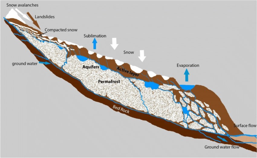
A rock glacier is a mass of rock, ice, snow, mud, and water that moves slowly down a mountain under the influence of gravity.
Formation - They typically form in mountainous regions where there is a combination of permafrost, rock debris, and ice.
A pre-existing glacier may accumulate debris and rocks as it moves.
Over time, if the glacier recedes or thaws, the debris-covered ice can transform into a rock glacier.
Permafrost - Thick ground layers frozen for at least 2 years
Types - They are classified as ‘active’ or ‘relict’ to indicate the status of permafrost within them, identified by the appearance of the rock surfaces.

Rock glaciers in Kashmir Himalayas - The Kashmir Himalayas dotted with these rock glaciers is facing deglaciation (retreat or melting of ice sheets and glaciers).
The study has pointed that rock glaciers will become a more common mountain landform in the future, as debris concentrations increase in the melting glaciers due to global warming.
The researchers found that some rock glaciers near glacial lakes in the region such as Chirsar Lake and Bramsar Lake particularly increase the risk of glacial lake outburst floods (GLOFs).
Down to Earth | Active permafrost structures identified in Jhelum basin
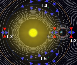
Aditya-L1 spacecraft was successfully placed in halo orbit around the Lagrangian point (L1).
A halo orbit is a periodic, 3-dimensional orbit that occurs near one of the L1, L2, or L3 Lagrange points.
These points are locations in space where the gravitational pull from two celestial bodies is equal.
It is called a halo orbit because the tracked orbit looks like a halo around the moon.

The Hindu | Aditya L1 placed in halo orbit
The Centre’s ambitious attempt to improve air quality in some of India’s most polluted cities suggests that a majority of Indian cities are far from making significant progress.
The goal of the National Clean Air Programme (NCAP) is to reduce average particulate matter (PM) concentrations 40% by 2026 (compared to 2017) in 131 cities.
PM 2.5 is considered the most dangerous grade of pollutant.
The aim was to cut pollution 20-40% by 2024 in cities, which was later shifted to 2026.
Status - Delhi has seen average annual PM 2.5 levels decline by 5.9%.
Navi Mumbai has seen a 46% rise in PM 2.5 levels and Mumbai saw a 38.1% rise and Ujjain, a 46% rise.
Jaipur and Visakhapatnam saw PM 2.5 increase 13% and 12% rise respectively and Pune 10%.
Reduction - Sharp decline in PM 2.5 from 2019-2023 were Varanasi, with a 72% average reduction in PM 2.5 levels and 69% reduction in PM 10 levels.
Agra too reported a 53% decline, as did Jodhpur with a 50% decline.
PM 10 - With respect to PM 10 levels, apart from Varanasi and Talcher, no other cities have met the 40% reduction target yet.
PM10 is particulate matter 10 micrometers or less in diameter.
The Hindu – Majority of Indian cities far from clean air target